The Baia dos Tigres (Tigers Bay) is a small isolated and unpopulated island in the southwestern region of Angola with a land mass of 98 square kms. As the largest and only sandy island off the coast of the 2000 km-long Namib Desert, it remains the least known coastal wetland along desert coast rich in shorebirds.
The Island was once a thriving commercial fishing community in the Portuguese colonial era, connected to the mainland by a small sand causeway. The inhabitants abandoned the Island in 1974 to escape the strong wind, lack of drinking water and the transportation difficulties to the mainland. Filled with hundreds of abandoned Portuguese-style buildings and properties, the structures are now being enveloped by the continual blowing sand.
Though the waters surrounding the island are very rich in fish stocks, the location is renown for its birdlife. Two surveys of the Island region in 1999 and 2001 indicated a rich wetland bird diversity consisting of 25 species and a bird density of 33 birds per square kilometer.
The Island is only visited now by adventure-seeking tourist groups. (AngoWebs - Angola)
Showing posts with label Landscape. Show all posts
Monday, February 2, 2015
Sunday, December 14, 2014
Uige: Historic Province Series
Uíge (pronounced:
"Weej") is one of the eighteen provinces in Angola and is located in
the northwestern part of the country. Its capital city is of the same name,
Uige.
During the Middle Ages, the Uige Province was the heartland of the Kongo Kingdom. The kings lived in the city of Mbanza-Kongo which had a population of about 50,000 in the 16th century and ruled with great authority in the region for several centuries.
The knowledge of metallurgy among the Bakongo was renowned as they became famous as iron blacksmiths; their king was even called the “Blacksmith King”. The arrival of Portuguese priests who lived at the king’s court and taught religion as well as literacy first strengthened their reign; their relationship with the Portuguese strongholds of the region was rather cordial and peaceful. Things changed incisively when the Portuguese started in the 19th century to conquer and occupy the territory of what at present is Angola..
In the early part of 20th century the province was on a economic decline due to its inhospitable terrain and poor accessibility. The situation changed entirely when the Portuguese discovered that soil and climate were favorable to coffee production. The Uíge province (then called "district") became Angola’s major center for coffee production in the 1950s. While part of the production came from European (mostly Portuguese) owned plantations, most producers were Bakongo smallholders. In times gone by, Uíge had the honour of being “the land of the red beans.” It was the leading coffee bean production area, when Angola was the fourth biggest producer in the world. Its market centre of Uige town, the district capital, prospered and was designated a city in 1956.
To encourage the principle of national integration with Portugal, many towns in Angola were renamed during Portuguese colonial rule, including the provincial capital of Uíge town, which was renamed Vila Marechal Carmona ("Marshal Carmona Town") after Marshal Óscar Carmona, the former President of Portugal, later simplified as Carmona.
Beginning in October 2004 and continuing into 2005, Uige Province was the center of an outbreak of Marburg hemorrhagic fever, a disease closely related to Ebola. Now under control, there were 374 cases with 88 deaths. According to the UN and was, at the time, the world's worst epidemic of any kind of hemorrhagic fever.
One of the natural beauty features of Uige is the Grutas do Nzenzo (the Nzenzo Grottos, one of the “7 Natural Wonders of Angola”). The Grutas are inside a strangely-shaped mountain with pointed stones that give it a somewhat solemn air. The term “Nzenzo” means “spring” or “source” of water since there is actually a spring inside the grottoes, flowing down from the cave roof at the large 'mouth' entrance. The internal rocky labyrinth is composed of various layers of stone, each overlapping the one below, giving it unmistakable rare beauty due to its distinct emerald green colors. (TAAG Austral Magazine, Wikipedia)
Tuesday, July 15, 2014
Choosing the 7 Natural Wonders of Angola
Following 10 months of public vote casting, the
7 Natural Wonders of Angola were chosen – the Tundavala
Fault in Huíla; the Maiombe Forest in Cabinda; the Nzenzo
Grottoes in Uíge; Lake Carumbo in Lunda-Norte; the Moco Hill
in Huambo; the Kalandula Falls in Malanje; the Rio Chiumbe
Falls in Lunda-Sul.
These were the beauties of nature in
Angola that received most votes from July 2013 to May 2014,
chosen from 27 finalists. Before the voting took place, six tele-
vision channels showed 27 short films with previously unseen footage of all the finalists. The six channels were TPA1, TPA2,
TPA International, RTP International, SIC International and TVI
International.
According to the organizers of the event, National Seven Wonders: “This was pioneering. Nothing like it had been done before in Angola.” There was also a road show, traversing the country’s 18 provinces, with live television cover- age of the finalists, the culture and the tradition of each area.
The choice of the 7 Wonders was part of the program “Amo Angola” (I Love Angola), billed as a way of “preserving the wealth of nature, highlighting the national heritage, promoting tourism and regional culture.” For the selection procedure, a scientific council was set up, comprising of representatives of the Ministries of Culture, the Environment, and the Tourism and Hospitality Industry, celebrities and well known figures from each of the country’s 18 provinces.
Angola became the first country in Africa to choose its Natural Wonders and is a first stage in the selection of the New 7 Wonders of the World, an initiative of the New 7 Wonders Foundation, which is headquartered in Zurich, Switzerland. It was set up in 2001 by the Swiss philanthropist Bernard Weber. (TAAG Austral Magazine 2014)
These were the beauties of nature in
Angola that received most votes from July 2013 to May 2014,
chosen from 27 finalists. Before the voting took place, six tele-
vision channels showed 27 short films with previously unseen footage of all the finalists. The six channels were TPA1, TPA2,
TPA International, RTP International, SIC International and TVI
International. According to the organizers of the event, National Seven Wonders: “This was pioneering. Nothing like it had been done before in Angola.” There was also a road show, traversing the country’s 18 provinces, with live television cover- age of the finalists, the culture and the tradition of each area.
The choice of the 7 Wonders was part of the program “Amo Angola” (I Love Angola), billed as a way of “preserving the wealth of nature, highlighting the national heritage, promoting tourism and regional culture.” For the selection procedure, a scientific council was set up, comprising of representatives of the Ministries of Culture, the Environment, and the Tourism and Hospitality Industry, celebrities and well known figures from each of the country’s 18 provinces.
Angola became the first country in Africa to choose its Natural Wonders and is a first stage in the selection of the New 7 Wonders of the World, an initiative of the New 7 Wonders Foundation, which is headquartered in Zurich, Switzerland. It was set up in 2001 by the Swiss philanthropist Bernard Weber. (TAAG Austral Magazine 2014)
Saturday, January 26, 2013
Golfing Angola: New Championship Course Opens
Until now, the golfing venues in Angola had been limited to a purely sand course in Benfica, situated just south of Luanda.
Recently, a new championship quality golf course has opened in Ingombota, a site along the Kwanza River, some 70 km or 1.5 hour drive from Luanda. Built on a land area of over 200 hectares beside the river, the 18-hole Mangais Golf Club and Resort course has a distance of 7000 meters. Designed as an ecotourism project to preserve the local environment and wildlife, the course incorporates 20 lakes and a 7.5 km canal that runs between the lush mangrove forest that encompasses the course.
Future plans for the golfing development incorporate the addition of two more 18 hole courses, a marina, airstrip and a 5 star hotel. http://www.mangais.com/en/
Monday, October 8, 2012
From "Guns to Roses". An Angolan Soldier's Story
For a
former number three of UNITA guerrillas, Antonio Urbano Chassanha, who hung up
his uniform in 1992 and is now based in Lobito, Angola's southern coast, the past
life of the military, has been changed into that of an entrepreneur, into a
branch of floriculture.
In
order to settle with accounts of the past and guard those past memories, he has
written two books, "Angola:
Onde Os Guerreiros Não Dormem” (2000)
(Translated: "Angola: Where The Warriors Don’t Sleep")
and “Esanju: A Rebelde Do Wambu” (2003)
(An Umbundu language title) on the
history and legends with ovimbundo traditions that pass from generation to generation
through the oral tradition.
Now
living in Catumbela, between Lobito and Benguela, Urban Chassanha explains that
now being refurbished from the Angolan Armed Forces, he does not want to spend
the rest of the days "sitting on the couch in front of a television."
Together
with his wife, Anabela, three years ago they had the idea of producing plant
species replantings and from there progressed to the production of ornamental
trees, plants and flowers.
"I
had a teacher who said that, ‘He who knows suffering better appreciates the
happiness of others.’ Indeed, creating life through seed matter, having
expectations for it to pop up, keeping up with its growth and then putting it in bag is a whole dynamic that gives us much
enjoyment, "he says.
Former
senior officer of the Armed Forces for the Liberation of Angola (FALA / UNITA),
Urban Chassanha was a deputy of the in the "Black Rooster" delegation
in the Joint Commission, a body created to oversee the implementation of the United
Nations sanctioned Protocol of Peace signed in 1994 in Lusaka.
Three
years ago, through his book writing and other events, his life changed and he
took on a role in a new vocation: gardening.
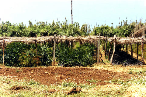
He opened his business, Lobitus Garden Horto and his new ambitions were
realized.
"We
experimented with indigenous trees, whose seeds were taken from an area between
Balombo and Bocoio (Benguela province). These plantings sprung up well and are in good
health, and in this success we have the ability, when we are asked, to produce
millions of species," says proudly.
Along
with him he has 42 employees who help him in the ‘process of creating life’,
which is the starting point in the rehabilitation of the living areas of
Angola.
Converted
to his new identity, Urban Chassanha considers that it has not been a difficult
transition from ex-guerrilla to florist.
"I
often say that the war did not create us many options. Peace creates us all the
possible options and gives us imagination. It was not at all difficult. I like
what I have done and have an interest in doing more, because it is an area that
gives me immense pleasure,” he emphasizes.
And
Angola? Does the country that is more than 10 years out a of civil war that
left thousands dead and maimed and destruction behind, ready to replace the
bullets for flowers?
"I
think the country has all the conditions to move forward. Weaknesses are
specific to a process that is not easy. Also, nobody naturally thinks of the facilities
needed for the future. It takes work. It
needs a lot of work," he says.
"I
believe that in time all wounds can be healed. He also notes, that he is very
pleased with the eagerness of people to learn more, forming an extremely
positive sign. Those of us, the older
people, are here to tell them the history "
"I
am giving a compass to create this project, but when I feel that this project
is up to speed, after a time I will devote
myself to writing," he concludes. (Lusa website)
Tuesday, September 18, 2012
Removing Angola's Landmines: The Remaining Task
MALANGE, Angola – Ten years after the end of the civil war in Angola, the country still remains, despite its best efforts, one of the most unexploded mine-affected countries in the world. The African nation was due to finish the demining by 2013, but the Angolan government is requesting a five-year extension to complete the task.
According to the United Nations Development Program, more than 80,000 people in Angola have been maimed by landmines since war broke out in 1975, and thousands more were killed. One out of eight Angolans lives in a landmine-affected community, and the 30 years of war have riddled all provinces with mines.
One of the NGO's working to de-mine the affected areas is the Norwegian People's Aid (NPA) which has 132 local employees and 2 international staff. Beyond the modern equipment and technology that Norwegian People's Aid's team uses rats in their demining efforts. Rats have an exceptional sense of smell and can be trained to detect explosives. Unlike metal detectors, they can detect both metal and plastic-cased landmines and can release up to 400 square meters of land per day.
NPA also relies on villagers to tell them where the mines and other explosive devices are located. The agency has teams to sensitize the people on the risks and on the danger of mines and other unexploded devices. They have observed that the villagers are very conscious of the dangers and when they find a suspected mine, they work with NPA to remove it.
The Norwegian NGO works with the national demining commission, CNIDAH, which coordinates the efforts of both NGOs and local demining teams. The commission monitors the operations all across the country.
CNIDAH's departmental head of operations, Brigadier Roque de Oliveira, says the government has put a great deal of effort into demining, because it is deemed crucial for the development of the country.
"For Angola to grow and develop, especially in agriculture, we need to demine. For Angola to build houses and schools that were destroyed during the war, we need to demine. And we need to demine railroads to improve development as well."
Besides agriculture, the country and the region also have the potential for tourism. Just a few kilometers away from the landmines are the third biggest waterfalls in Africa. Ten years ago, few people would venture here. Today, it has become a popular place for locals and expatriates to visit.
The Angolan government has recently asked for a five-year extension to finish demining, arguing that only 40 percent of the job has been completed in the past decade. (Voice of America)
Saturday, May 19, 2012
Angola's Shipwreck Beach

Some 20 miles north of Angola's capital, Luanda, lies a stretch of beach that is an eerie resting place for 20 + derelict and rusting ships. Known by locals as Praia da Santiago or Praia do Sarico, the 1.5 mile stretch of beach is better known as Shipwreck Beach or Karl Marx Beach, named after the biggest shipwreck on the beach. Off shore and along this stretch of beach are dozens of rusting hulks of tankers, cargo ships and fishing vessels. Many legends have been passed along concerning how the large ships mysteriously arrived there. But in reality, with the absence of salvage facilities, the most likely explanations for this site is that the ships were removed from Luanda harbor after being unseaworthy. Either the ships were intentionally grounded onshore on this beach or their offshore moorings rusted through and the tide and currents pushed them ashore. Truly an incredibly photogenic spot.
Thursday, January 6, 2011
Replanting Angola
Angola is listed as having one of the largest areas of planted forest in Africa, composed for the most part of eucalyptus (85 percent), pine and, to a lesser extent, cypress. The land considered forested covers about 53 million hectares, about 35% of the country's total land area. However, the area of forests considered economically productive is estimated at 2 373 000 ha, about 2% of the country's area.
Most of the plantations belong to private enterprises (mainly the Railways and the Cellulose Company), while the remainder are State property, managed by the Ministry of Agriculture and Rural Development. The Benguela Railway's eucalyptus plantations in the center of the country are some of the largest in all of Africa, originally planted to provide firewood for their steam locomotives.
Unfortunately, and conversely, Angola has an estimated deforestation rate of 5%, one of the highest rates in southern Africa. Zaire province in the north has the highest national rate of deforestation and few forested areas remain in that region. Most of the plantation areas have been degredated as a result of burning, felling for fuelwood and charcoal production, pest and disease problems, and soil degradation.
With an acknowledgement of the need to assess and address the forestry needs after many years of environmental distress from the civil war, the Angolan government recently invited the United States Forest Service (USFS) to Angola to provide forestry evaluations and technical assistance in rehabilitating the resource. Tree planting campaigns have been initiated in schools and other municipal departments in efforts to replant and protect the forestry resources.
Thursday, September 30, 2010
One of Angola's Natural Wonders.
Angola is home to some relatively unknown treasures of this world. As spectacular as any other world-wonder, the Black Rocks of Pungo Andongo rise up majestically over the African savanne landscape. Known locally as the Pedras Negras de Pungo Andongo, these rocks are one of the main tourist sites of the Malanje province. They are steeped in history and intrigue, since no one really knows how the colossal rocks, some up to 200 metres high, came to be here as their geological formation is out of keeping with the surrounding savannah.
Legend has it that in the sixteenth century, Pungo Andongo was the capital of the ancient Kingdom of Ndongo ruled by King Ngola Kiluanji and Queen Ginga Mbandi. Rock carvings found there are said to represent footprints of the fleeing queen who was disturbed by soldiers as she bathed in a stream at the foot of the stones.
In later years, the Portuguese established a military fort among the rocks which was notorious in Portugal. Its name was used to scare naughty children, their parents telling them they 'would end up in Pungo Andongo" if they misbehaved. In the 1920's political prisoners were held at the fort and during Angola's civil war the rocks were a key battleground between opposing forces. (Sonangol Universo Magazine, Sept 2010)
Subscribe to:
Posts (Atom)


